भारतीय अंतरिक्ष अनुसंधान संगठन, अंतिरक्ष विभाग
Indian Space Research Organisation, Department of Space
भारत सरकार / Government of India

Geospatial Himalayan Information and Monitoring System
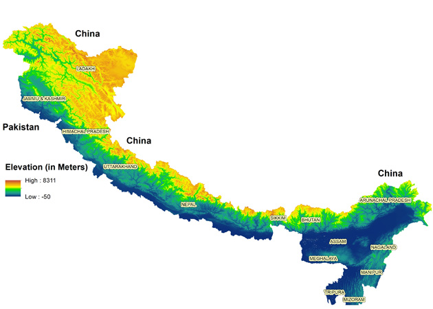
Himalayas are a mountain range in Asia, separating the plains of the Indian subcontinent from the Tibetan Plateau. The Himalayas form a nearly 3000 km long, 250-350 km wide range between India to the south and the huge Tibetan plateau, with a mean elevation of 5000 m, to the north.
The Himalayas consist of parallel mountain ranges: the Sivalik Hills on the south; the Lower Himalayan Range; the Great Himalayas, which is the highest and central range; and the Tibetan Himalayas on the north.
The flora and fauna of the Himalayas vary with climate, rainfall, altitude, and soils. The climate ranges from tropical at the base of the mountains to permanent ice and snow at the highest elevations.
The rivers of the Himalayas drain into two large river systems viz. The western rivers combine into the Indus Basin. The Indus itself forms the northern and western boundaries of the Himalayas. It begins in Tibet at the confluence of Sengge and Gar rivers and flows north-west through India into Pakistan before turning south-west to the Arabian Sea. It is fed by several major tributaries draining the southern slopes of the Himalayas, including the Jhelum, Chenab, Ravi, Beas and Sutlej rivers, the five rivers of the Punjab. The other Himalayan rivers drain the Ganges-Brahmaputra Basin. Its main rivers are the Ganges, the Brahmaputra and the Yamuna, as well as other tributaries. The Brahmaputra originates as the Yarlung Tsangpo River in western Tibet, and flows east through Tibet and west through the plains of Assam. The Ganges and the Brahmaputra meet in Bangladesh and drain into the Bay of Bengal through the world's largest river delta, the Sunderbans.
The Himalayas are home to a diversity of medicinal resources. Plants from the forests have been used for millennia to treat conditions ranging from simple coughs to snake bites. Different parts of the plants – root, flower, stem, leaves, and bark – are used as remedies for different ailments. For example, a bark extract from an Abies pindrow tree is used to treat coughs and bronchitis. Leaf and stem paste from an Andrachne cordifolia is used for wounds and as an antidote for snake bites. The bark of a Callicarpa arborea is used for skin ailments.Nearly a fifth of the gymnosperms, angiosperms and pteridophytes in the Himalayas are found to have medicinal properties, and more are likely to be discovered.


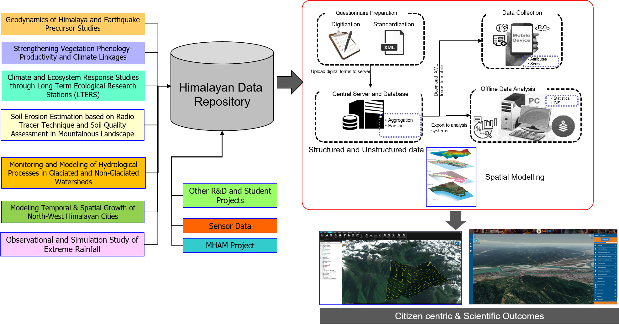
The SDSS provides 2D and 3D map visualization of the thematic layer specific to the Himalayas. Under 2D visualisation it provides basic GIS based navigations- Zoon-in, Zoom-Out, Area & distance measurement, point, line & polygon based queries, pixel based query (on raster image), zoom to layer tool, layer swiping & transparency tool, layer metadata display, add layer (WMS, KML, JSON only), AOI based query (draw only), alert display, time series data visualization (slider or any other appropriate tool). Whereas under the 3D Visualisation the functionalities like Basic navigation, generation of slope map, slope with direction, contours, terrain profile, create fly-through, horizontal and vertical height measurement etc. are provided. The SDSS also provides visualization of data obtained from the Automatic Weather Station Installed across the Himalaya, statistical report generation of the data, query by date and duration, generation of interpolated maps like temperature, rainfall, snowfall etc. Alert generation based on threshold level.